PAPER ABSTRACT: Water models are world-making devices that stabilise or remake social structures and power relations. This has spurred calls for deeper explorations of how models are situated within historical and political contexts. The paper examines the flood model used for flood management planning in the River Poddle catchment in Dublin, Ireland. Starting from the death of Celia de Jesus during a 2011 flood in this catchment, we argue that Dublin’s neoliberal property regime is an essential context for situating this model. Using a method grounded in discourse analysis and interdisciplinary dialogue, our situating approach follows the modelling process across two levels: the policy context and the model outputs and outcomes. Irish flood management policy sets strong boundaries for modelling, while embedding property assumptions in the model’s aims, scenarios and maps. Model outputs are shown to effectively serve the interests of real estate actors while negatively impacting those marginalised in property relations. Our critical situating has important implications for those hoping to use or critique models in order to challenge injustice.
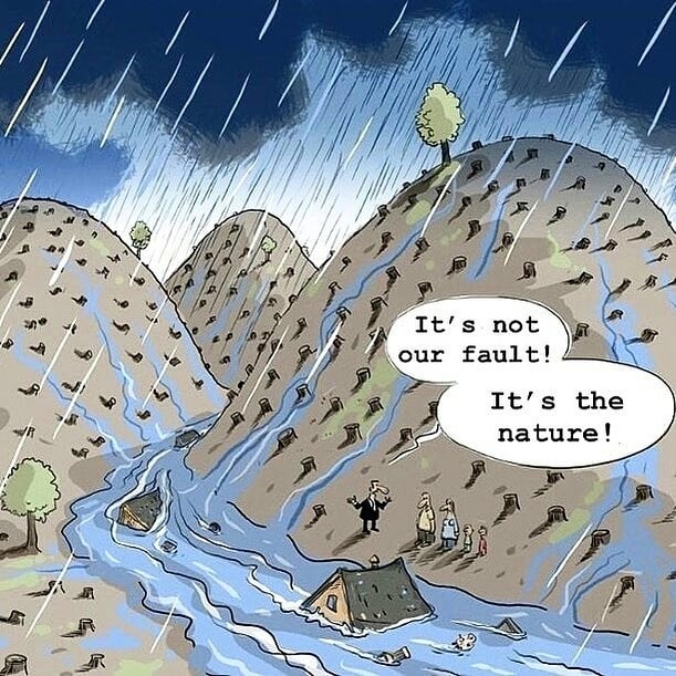
“There comes a point where we need to stop just pulling people out of the river. We need to go upstream and find out why they’re falling in.”Desmond Tutu
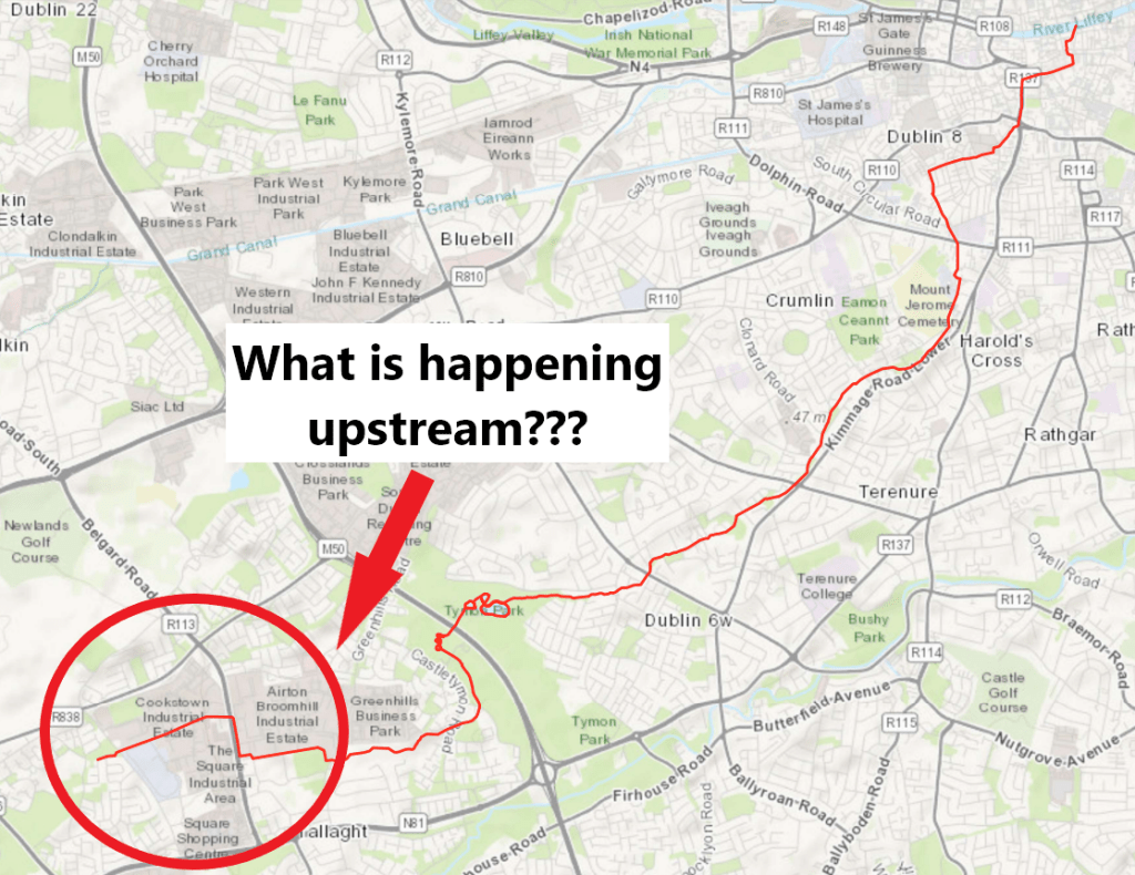
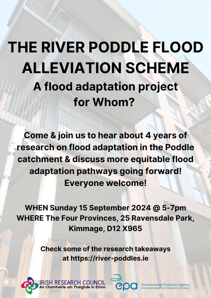
What is happening in the upper part of the river Poddle catchment?
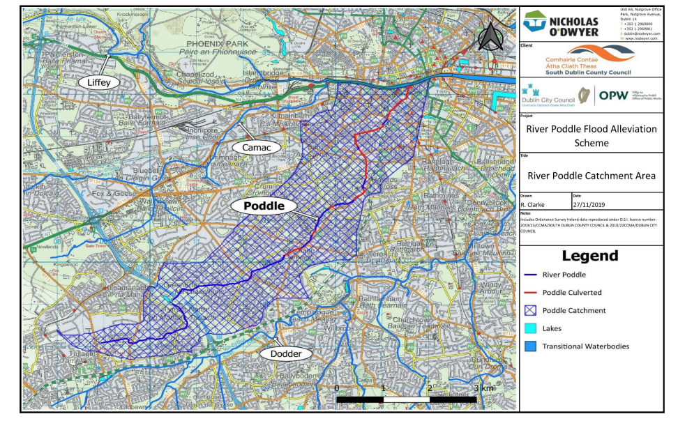
The river Poddle
On paper, in this part of the catchment, looking at the Tallaght Town Centre Local Area Plan 2020-2026, plans were to re-open the river culvert wherever possible and to uncover its source in Cookstown. However, we are now in March 2025 and none of these plans has been realised. As most objectives of our urban development, plans to daylight the river Poddle are to be implemented by private “developers” and “in tandem with development”, but they have little interest in doing so. On the contrary, in the current real estate market policy context, their interest is to maximise land surface development opportunities, which is clearly at odds with making room for the river Poddle. Entrusting private actors with taking care of our rivers is a pipe dream. Our state and local government agencies themselves are actively supporting the erasure of the upstream part of the river Poddle by mapping its culvert as a surface water sewer. Planning applications that do so are also systematically approved. It results in the river Poddle being dropped from environmental, ecological and flood risk assessments at this location and there is little doubt that it will impact the entire catchment negatively.
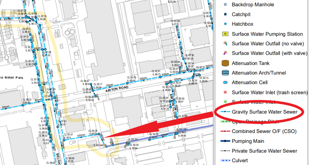
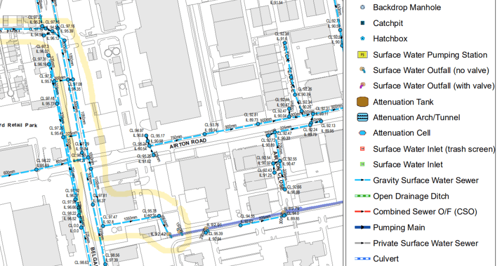
South Dublin County Council mapping of the river Poddle culvert as “Gravity Surface Water Sewer”
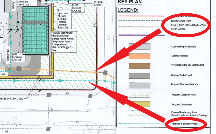
Amazon mapping of the river Poddle culvert as “Surface Water Sewer” and proposal to divert it to make room for their second Airton Road data centre (planning application: SD18A/0219)
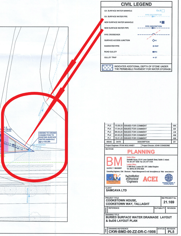
The river Poddle culvert mapped as “surface water pipe” and connected to “new surface water pipe” to be added as part of a forthcoming development (planning application: SD23A/0237)
The river Poddle culvert mapped as a mere existing pipe on the site of a new development (planning application: SD20A/0050)
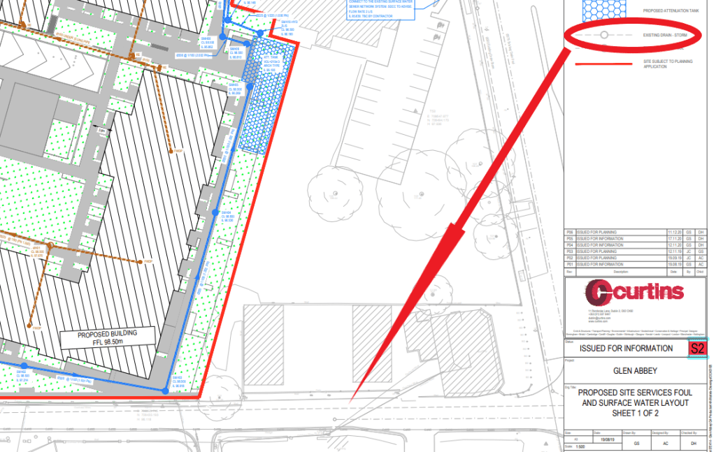
The river Poddle culvert mapped as “existing drain storm” (planning application: SHD3ABP-309916-21)
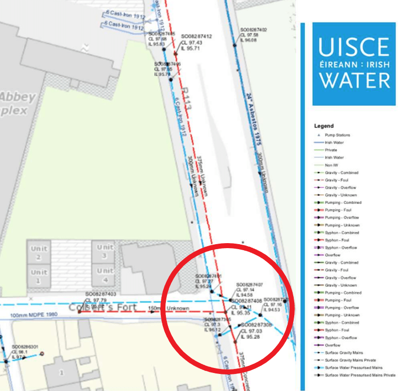
New development surface water drain connected to the river Poddle culvert mapped as “Surface Gravity Mains” by Irish Water (planning application: SHD3ABP-309916-21)
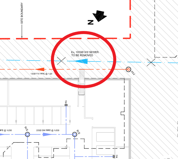
River Poddle culvert mapped as “SURFACE WATER SEWER TO BE REMOVED” on plans for a new development (planning application: SHD3ABP-305763-19)
River Poddle mapped as “Unnamed Drainage Ditch” in ‘Appropriate Assessment – Stage 1 – Screening Report’ for a new development (planning application: SD19A/0346)
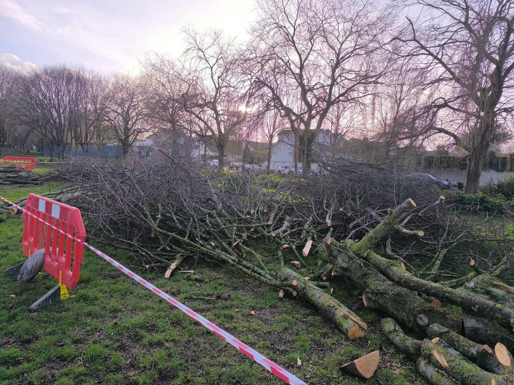
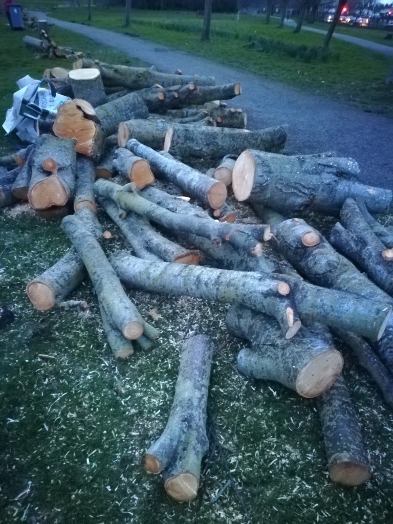
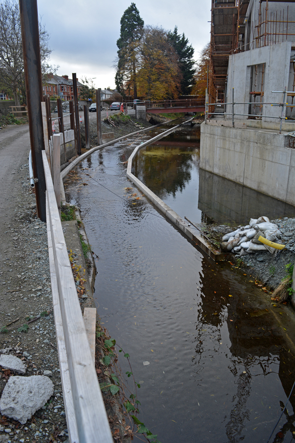
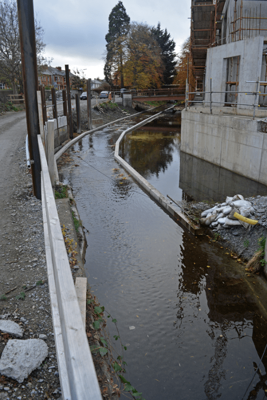
Tree removal as part of the river Poddle flood alleviation scheme works in Ravensdale Park (February 2025)
Tree removal as part of the river Poddle flood alleviation scheme works in Tymon Park (February 2024)
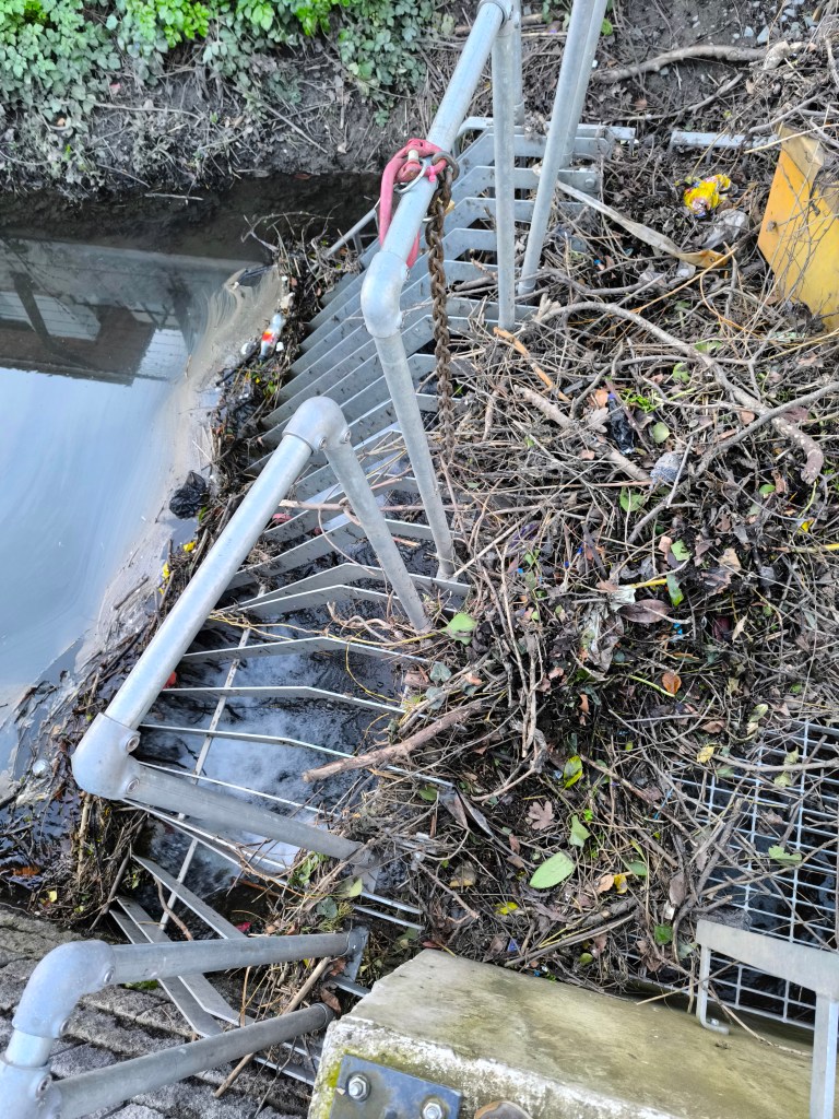
River Poddle trash screen left unmaintained for days at Mount Argus Apartments in February 2025 (owned by global real estate investment fund Patrizia who has currently €56bn of assets under management)
New build-to-rent by Rivergate Developments meters away from the river Poddle in Flood zone B in well-known flood-prone location (September 2024)
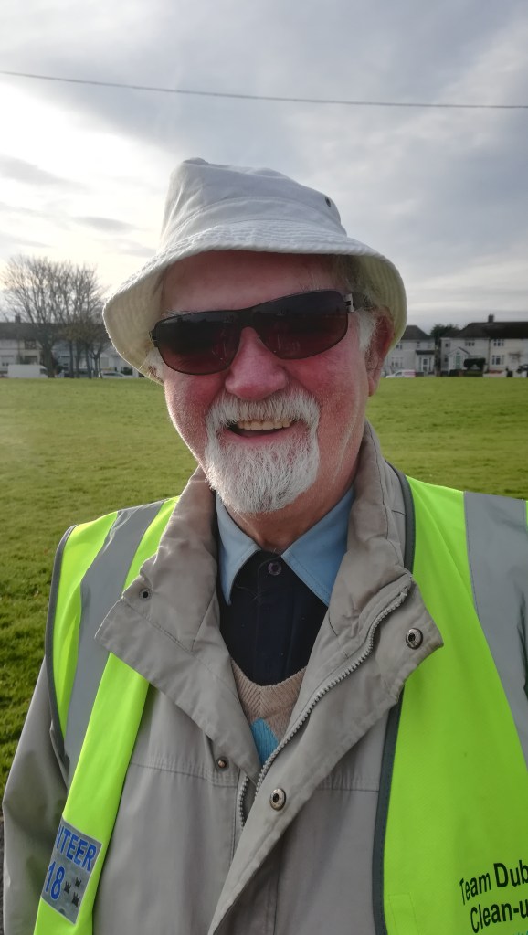
“My earliest memory of the Poddle is my Dad, I was only a young lad, 8 or 9 years of age, and my Dad would take me on the crossbar of the bike and we would go up to the Poddle and fish, we call it pinkeens, the little fish, but now and again, when I was with my Dad, we’d seen a catfish and I thought they are very lovely-looking (…) that was one of my happiest memories.”
CHAPTER 1 For me, it all began back in 1942 when I was 4 years old. My Dad would say to me “right hop up on the crossbar of the bike”. He would take me down to the Grand Canal and we would feed the swans, ducks and seagulls. That was my first taste of nature. I used to love this. We would continue on our journey all the way down to Sandymount Strand. I used to be fascinated at the way the sun would shine on the water and create ‘Diamonds’. Even since when I see ‘diamonds’ on the water I think of my Dad. As I am now 82 that was a long time ago.
CHAPTER 2 Other times he would take me fishing for pinkeens up to the river Poddle. I loved the river and the sound of running water. I joined the Crumlin Community Clean-up Group in 2019 and one of our tasks was the clean-up of the river Poddle. It brought back happy memories. I always thought that it was very uncaring of people to pollute the river like this. The clean-up group were really lovely people. I am so glad to have them in my life.
Sean on his way to a river Poddle clean-up (November 2019)
CHAPTER 3 “Our Gang” on Kells Road loved going for rambles up to Lady Shaw’s Woods. It is also known as Bushy Park. It is a well-kept beautiful park with its lovely lake packed with wildlife. One of my old-time favourite sights is to see “diamonds” on the lake and a swan family preening themselves. My love of the beauty of nature is being carried on by my family and grand children. I would tell them all about my childhood adventures and the fear we had of Lady Shaw who lived in the big haunted house behind the magic house. The haunted house was now gone. Many are the films I compiled of this beautiful lake so well-maintained with its abundance of wildlife. We would then go fishing for pinkeens on the river Dodder. I used to swim here a lot as a young lad.
Sean leading our walk in Bushy Park (June 2020)
CHAPTER 4 My wife had the same love of nature as I. We used to love going to the Pine Forest and walking by the mountain stream down through Glendoo Valley and down to Johnnie Fox’s Pub where we had our lunch. We loved the area so much that in 1995 we bought our grave up in Mount Venus Cemetery. My wife Rita passed away in 2013. So many memories come to my mind when I pay her a visit. One time my son John and family took Rita and I for a spin up to the Pine Forest. We had our picnic by a mountain stream. I just love the sound of running water. We cooked sausages on the open fire. They were as black as cinders when cooked but we still ate them. We all survived that. I swear I can still get the smell of burnt sausages when I am in the area.
CHAPTER 5 As a young lad I went for a ramble with my pals and eldest brother Seamus. We went to what had been a quarry up on Whitewall Road, just pass the Submarine Pub. It was being landscaped and the quarry lake was being stocked with fish (the lake has since been filled in and is now a football field called the Eleven Acres). My brother Seamus had gotten a new fishing rod. I asked could I have a go and he said no. I made up my own fishing rod. I got a piece of stick, my shoe lace and a bit of wire. Well, surprise, surprise, I was the only one to catch a fish. I was so proud. I kept that fish at home in the bath. When anyone wanted to have a bath, they had to take out the fish and put it in a basin. I had made a net for this purpose from one of my mother’s nylon stockings. I had Jonah the fish for 6 months before he died. I was heartbroken. Nemo was not a patch on him.
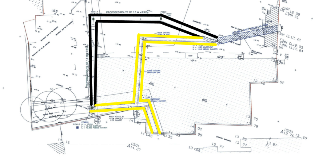
In 2020, the river Poddle flood alleviation scheme planning application was submitted to An Bord Pleanála for review. At this stage of the process, residents who wished to submit observations had to pay a €50 fee. In 2023, the proposed flood scheme was approved, and, in April 2024, the flood scheme works were launched in Tymon Park, South Dublin. However, if we look at Flood Risk Assessments in planning applications, we can see that the implementation of the flood alleviation scheme was decided and agreed on long before the planning application was submitted to An Bord Pleanála for review! While we are made to believe that our voices count and asked to pay €50 to make them heard, public authorities and private developers are the ones and only decision-makers!
In 2015 for instance, a planning application for a student accommodation in the Liberties was approved on the basis that the river Poddle flood alleviation scheme would soon be completed (planning application reference: 3475/14). The development site intersects with the river Poddle culvert, is located in flood zone B and plans required the diverting of one of the river overflow culverts. The developer was Global Student Accommodation, which is now “located in nine countries with circa $6 billion of assets under management” and the “trusted partner globally to some of the world’s leading institutional investors”. The 2014 Flood Risk Assessment states that “the possible flood risk along Mill Street should be completely mitigated” by the proposed river Poddle flood alleviation scheme, and that based on conversations with Dublin City Council, the scheme “is approximately 2 years from commencement” (consultant: Barrett Mahony). In other words, 9 years prior to the scheme statutory planning approval, developers had already received the assurance that it would be implemented!
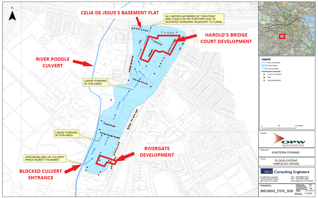
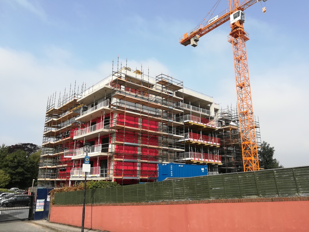
Two other developments located in flood zone B and on the 2011 Harold’s Cross flood extent map tell a similar story. The first one is a build-to-rent apartment project led by Dublin and London-based property developer Rivergate Developments. The development was approved in 2019 on the basis that flood risk would be mitigated by the forthcoming river Poddle flood alleviation scheme (planning application reference: 0374/20). However, the Flood Risk Assessment submitted as part of the planning application was produced before the publication of the first official design of the scheme in 2018 and therefore based on initial rough drafts (consultant: JBA). Furthermore, as in the Liberties development case, there are obvious signs of ongoing conversations between the developer’s consultants and public authorities and again it seems taken for granted that the scheme is to be implemented shortly whereas at this time it had not even reached planning submission stage: “Construction is due to begin in 2020, with completion in 2022.”.
The second one, Harold’s Bridge Court, differs slightly in that it was approved in June 2024 so after the commencement of the flood scheme works in April 2024 (planning application reference: LH29S.319421/LRD6036/24-S3). However, the Flood Risk Assessment, published in 2023, refers to similar exchanges between the developer’s consultants and the local authority and to a similar engagement that the proposed flood scheme is to be implemented in the near future before it is formally approved in 2023: “Following discussions with the DCC Flood Defence Projects Office in June 2022 we note these works are now due to commence in 2023.” (consultant: DBFL)
The Rivergate build-to-rent development in Harold’s Cross
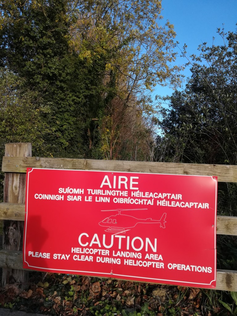
A few years ago, a local resident and historian asked the Technical University staff to put up two “Poddle River Walk” signs on their Tallaght campus where the river flows. The resident “thought it was important (…) to make it more visible”.
Recently, one of the river walk signs was removed and replaced with a “helicopter landing area” sign.
Returning to a past event that involved a loss of life as did the Dublin 2011 flood event cannot be anything but incredibly painful, especially for those closest to the victim. However, assessing the event is also crucial to locate any potential failures that may have caused it and should be avoided at all costs in the future, which is what this short article focuses on.
On the night of 24th October 2011, during the worst Dublin flood event of the last decade, Celia de Jesus was trapped in the Harold’s Cross basement flat she was renting at the time and died as a result. The dominant narrative surrounding her death has been that she was killed by the flood after the river Poddle burst its banks. The Dublin District coroner verdict “Drowning as a result of a surge of water and flooding over a short period of time following two days of heavy rain” (Coroner report, 2012) and Office of Public Works (OPW) appointed consulting firm statement that she was “trapped by flood waters” confirm such a reading of the tragic event.
In response to the 2011 flood event and tragic death, a flood alleviation scheme (FAS) was designed for the river Poddle, and works are now underway after the FAS was approved by An Bord Pleanála in 2023. The €10m FAS (originally €7m) is managed by the OPW in conjunction with Dublin City Council (DCC), South Dublin County Council (SDCC) and consulting firm Nicholas O’Dwyer. It consists of a mix of hard and soft defences to be implemented at catchment level.
Based on a four-year PhD research project, this article presents data that challenge the river Poddle FAS as the most appropriate response to the tragic event. Instead, data expose the tragic death as the prime result of ongoing flood maladaptation in the catchment. Drawing from research organized around two periods of time that extend before and after the 2011 flood event, I outline how flood adaptation governance in the catchment is largely driven by the imperatives of the real estate, rental and insurance markets. In the process, the ‘unpropertied’ are further marginalized. From this perspective, Celia de Jesus’s death cannot be attributed to “heavy rain” but must be seen as the result of uneven systemic/structural forms of (flood) endangerment, what Engels famously coined social murder.
1985 to 2011: relentless engineering & development
Flood governance in the Poddle catchment has long been driven by the assumption that engineering could address ongoing flood-prone development, with hard infrastructures and other heavily engineered interventions being seen as the solution. If hard infrastructure failures appear in flood reports, they rarely seem to be acted upon. In 1985, for instance, a large section of the river Poddle culvert located on Lower Kimmage Road collapsed. One year later, Hurricane Charley hit the country and caused one of the worst flood events ever experienced in Dublin. During the flood event, the culverts of the river acted as major aggravating causes due to blockage and low capacity. Despite such failures, the main response to Hurricane Charley by DCC was to build more culverts.
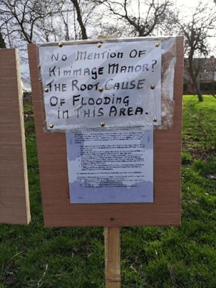
The year of 1997 illustrates how flood engineering in the catchment was heavily driven by developers’ agenda. To address flood risk posed by a large development project in Kimmage Manor, SDCC created a set of flood alleviation ponds in Tymon Park South (SDCC, 2001). “Over 100K cubic metres of earth were excavated” (SDCC, 2001) to build the ponds. Led by Flynn & O’Flaherty Properties Ltd, the development comprised 336 houses and 24 apartments at a price of up to £290K for the houses.
Local residents calling out the lasting impact of the Kimmage Manor development (2020)
Parallel to the ongoing engineering and lucrative development of the catchment, many signs pointed to the flood vulnerability of tenants living in and around what would become Celia de Jesus’s home in 2011, but these were ignored. In 1986 for instance, several Harold’s Cross houses and their basement were flooded during the event, including the property where Celia de Jesus would live in 2011. The basement resident of 1 Parnell Road, only two doors away, reported a 73cm water level. Subsequently, in 2009, Celia de Jesus’s future place of residence was also described as follows in a planning application submitted to DCC: “The said property, which is in multiple occupancy, is not of a habitable standard” (Don Harrold MRIAI Architect, Conservation methodology statement). At the time of the 2011 flood event, the property was found to be divided into five rental units including two at basement level.
The 2011 flood event: a tenant’s flood trap
A few days prior to the 24th of October 2011, unusually heavy rainfall affected the Dublin region and initiated a flood event that unfolded in many parts of the city on the evening of the 24th. In the river Poddle catchment, as in 1986, the flood event developed in ways that clearly challenged our overreliance on engineering as a main way to alleviate flood impact. Only a decade after their completion, the Tymon Park South flood ponds proved insufficient in containing excessive water flow and, as in 1986, culvert failure acted as a major aggravating factor in the way the flood event unfolded.
When the flood water finally reached Celia de Jesus’s basement flat, she was unable to open her entrance door, which was the only means of escape at her disposal as the only window of the flat was blocked with metal bars (Tenant deposition in Coroner report, 2012). In addition to the lack of alternative means of escape, the inspection conducted in the property after the flood event revealed many breaches of fire safety guidelines affecting all five rental units (Senior Executive Fire Prevention Officer deposition in Coroner report, 2012). However, despite all evidence to the contrary, the death of Celia de Jesus was attributed to heavy rain and relayed as such in the medias.
In December 2011, only two months after the death of his tenant, Celia de Jesus’s landlord submitted a new planning application to DCC to reunite the 5 rental units of his property into 1, which was approved. In 2015, the property in which Celia de Jesus died was sold at a price of €535K and it is now registered on the RTB’s register as a 6 bedroom rental property (August 2024).
Also in 2014, to further safeguard the real estate market in the face of increased flood risk, the OPW signed a memorandum of understanding with Insurance Ireland. As summarized by a local councillor, problems getting flood insurance keep people “from buying and selling”. However, while the memorandum places significant obligations on the side of the OPW, it does not oblige insurers to provide flood cover. Importantly, the memorandum constitutes a formal commitment to aligning our flood adaptation governance with what matters to insurers: heavily-engineered flood relief infrastructure (a €1.3 billion budget for the 2021-2030 period), 1% AEP (Annual Exceedance Probability) flood events and, centrally, properties.
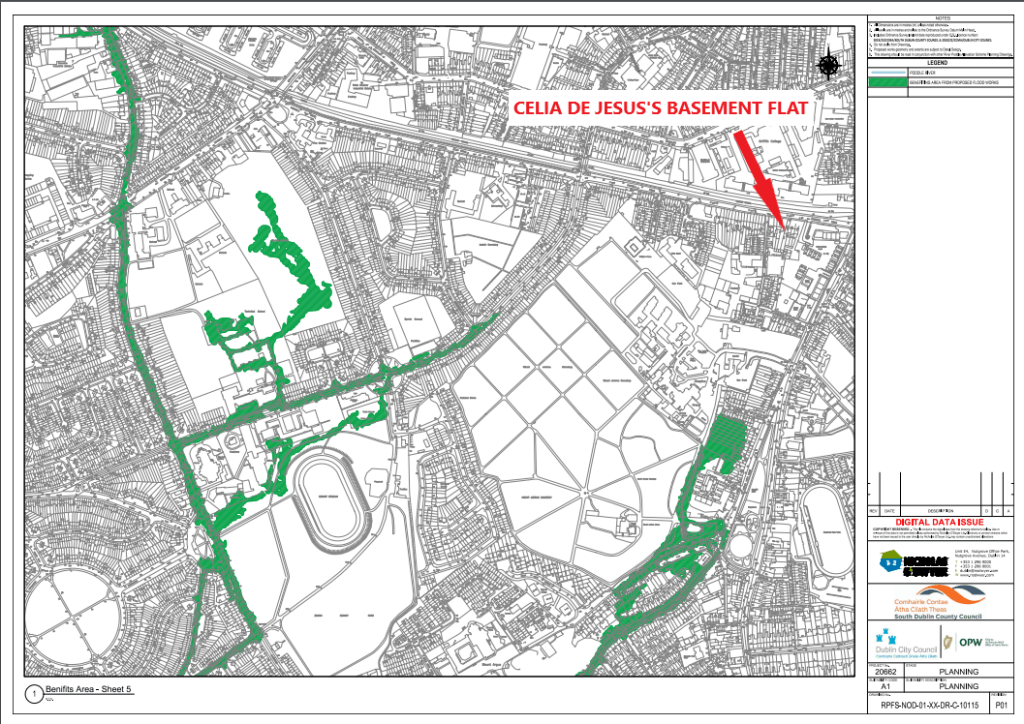
Works for the new river Poddle FAS were launched in April 2024. Most public debates about the flood scheme that preceded its formal approval were centered on insurance access. One of its central pieces is the upgrading of the Tymon Park flood ponds, those first created in 1997 and which proved ineffective in 2011. Most importantly, the scheme allows for the production of a map of “benefitting areas” under a 1% AEP flood event scenario, a key requirement of insurance companies. People owning property in these ‘protected’ areas will be able to (re)claim flood insurance and, if successful, will see the value of their property increase accordingly. Meanwhile, the focus on what matters to insurers dissociates even further the flood scheme from its initial objective, which was to address the death of Celia de Jesus: the basement in which she died is not part of the 1% AEP flood map and map of benefitting areas produced as part of the scheme. This is how a new maladaptation cycle is closing and setting the path for those to come.
The flood management approach adopted in the river Poddle catchment between 1985 and 2024 signals ongoing maladaptation. Despite numerous failures and limitations, our dependency on flood engineering and flood insurance is ever increasing. Millions of public euros are injected in the building of 1% AEP event protective infrastructures in the hope that insurers will take them into account, but they have no obligation to do so. In turn, the approach continues to fuel the overdevelopment of flood-prone areas, which results in increased residual risk. While highly profitable to real estate market actors at large, it leaves tenants unprotected or even at increased risk exposure for those most precariously housed. The death of Celia de Jesus does not stem from heavy rainfall but is the result of such a flood adaptation approach. In this sense, it must be seen as a social murder.
The social murder lens has two main implications for future flood adaptation intervention: first, as described at length, the killing of Celia de Jesus and its framing involve a wide range of public/private actors at all levels of society across large temporal/spatial scales. Therefore, finger-pointing individuals, institutions, regulations will not address the flood maladaptation that killed Celia de Jesus. What is required as a matter of urgency is to challenge the political economy driving our current approach to flood adaptation: the assumptions that make us believe that protecting markets is more important than protecting lives. There are inherent contradictions between the two endeavours that can never be reconciled.
The second main implication of social murder is that it extends far beyond the death of Celia de Jesus: it points toward a lack of basic flood protection for all ‘unpropertied’ of Ireland. Should future flood adaptation interventions fail to consider the death of Celia de Jesus as what it stands for, which is that wider systemic/structural flood inequities must be addressed as a matter of urgency, they will only contribute to fuelling ongoing flood maladaptation and its social murders.
Laure de Tymowski (30/08/2024)
Offline sources
Report on the death of Celia de Jesus produced by the Dublin District Coroner in 2012.
“Tymon Park” published by South Dublin County Council in 2001.
Acknowledgements
I would like to thank All who took part in the research process as well as in the writing of the present article.